Anisabel Veríssimo e Costa, who was part of the panel of speakers at the round table on the Pillars for the Development of the Sea Cluster this Wednesday, at the 3rd Conference on the Economy and Market on the Blue Economy, said that nautical charts are out of date, belonging "many of them at the time of independence".
"At the moment they are being elaborated in partnership with the Hydrographic Institute of Portugal [IHP], because we signed a cooperation agreement in 2021, so that this institute can help us in collecting data to update our nautical charts", said the president of the National Maritime Agency, created a year and a half ago.
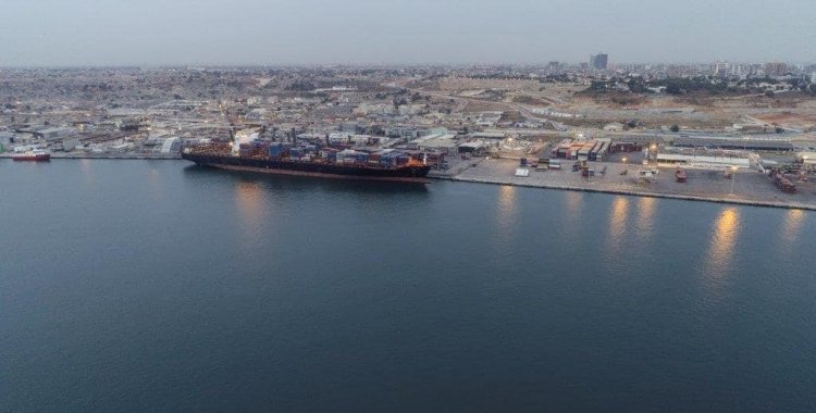
Information disclosed, in July 2022, by the Portuguese Navy on its website reported that the first edition of the new Nautical Chart 16303 – "Porto de Luanda", had been published, providing "a response to the need to update the nautical cartography of the ports of Angola".
This new chart cancels chart 360, which had been produced with data acquired by the Hydrographic Mission of Angola and São Tomé between 1967 and 1969.
For the production of the new nautical chart of the port of Luanda, hydrographic data acquired by the Hydrographic Brigade in December 2021, within the scope of the Mar Aberto Mission, a work carried out in collaboration with the National Maritime Agency of Angola, which had the participation of a group of hydrographers from the Angolan Navy.
At the time of signing the cooperation protocol between the two countries' institutions, the then Secretary of State for Civil Aviation, Maritime and Ports, Carlos Borges, said that 95 percent of Angola's import activity goes by sea, informing that the agreement was part of the national maritime strategy for State reforms, aimed at ensuring better navigation of national and international maritime transport.
The Portuguese side, represented by the general director of the IHP, Carlos Soares, said that the protocol would allow transmitting knowledge to Angola so that the country becomes increasingly autonomous in the sense of being able to deal with its nautical cartography.
The official indicated that in the next ten years, taking into account that Portugal holds the hydrographic and cartographic data of the African country, all information will be passed on to the Angolan authorities.